Looking4Cache
Geocaching App for iPhone and iPad

Thank-you discount
Nearly a month ago I released the version 2.0 of my geocaching app. This updates brought a complete revised user interface and a lot of new functions requested by the community.
The first bugfixes are done. Out of the community I got a lot of support and the amount of good reviews and 5 star ratings (at least here in Germany) showed me, that the lot of work during the winter was worthwhile.
To welcome the early spring (also at least here in Germany 😆 ) and say thanks encouragements I will drop the price over 50%. For one week the Pro version will cost only $3.99 instead of $8.99.
Have fun outside, Thorsten
Looking4Cache gets a major update
Finally! After nearly a half year of coding and testing the generally recondition and extended version 2.0 of L4C goes live.
In this version I spend a lot of attention on the usability but also done some functions requested frequent since a long time. I hope you will like it.
When starting the new version the first time you will see a welcome screen containing a video. If you installed a update you will see the “Whats new” video. In terms of usability I also created a “First steps” video for fresh installs.
Here you can see them too:
Video – First Steps (en)
Video – Whats new in V2.0 (en)
Have a lot of fun when caching with the new version and hopefully not to much trouble with the sure existing bugs 😉
mAPP – offline mapping app
I just released my second app: mAPP. It is a offline mapping app and a gpx track recorder.
mAPP is designed for all people leaving the big streets and need orientation like hikers, cyclists, geocachers and backpacking tourists.
The app itself can be downloaded for free from the AppStore. Functions like displaying online maps from OpenStreetMap and OpenCycleMap, recording and displaying of tracks and saving waypoints are included.
For small fees (InApp Purchases) you can download offline topo maps of the whole world. There is a map for every country worldwide or for bigger countries maps for each state. This maps are saved in a space saving vector format and contains nearly all details of OpenStreetMap. Also included are contour lines I calculated from NASA data. The maps will be refreshed each month.
For the start the maps of the german speaking countries are reduced about 50%.
www.offlinemap.info
facebook.com/offlinemap
mAPP in the AppStore
Also you can see it as a sneak preview for the new design and the topo maps of L4C 2.0 which will be released in the next days.
Offline Vector Maps
Since some days Looking4Cache has a new interesting feature: Vector Maps!
Within the app you can download maps for nearly the whole world out of the Download Center. Large Countries divided in their states to keep the file sizes small. If you downloaded a map once, you can use them within the app for offline geocaching.
In the new version there are to display modes of the maps:
- In the ‘Live’ mode each map section will be rendered in the requested zoom level. This is very detailed and always sharp. Depending on the device and the requested zoom (the amount of details to show) this takes some time to render.
- In the second (and new) mode small images will be rendered in 22 zoom levels as soon as they should displayed. This images will be saved to a cache database in the same way you maybe know from the online maps. If you want to view a already rendered area for a second time, L4C uses the cached images. By this technic the viewing is approximately as fast and smooth as a online OSM map with a fast internet connection.
There is one remaining bug in the vector maps: If you use the vector maps a long time without restarting the app it can crash. This mostly occurs when switching between maps or changing the render mode. After starting the app again you can use the app again. I am already working on a fix for this issue, but I think also with this the vector maps are a benefit for the app.
Google Maps integrated in L4C
A short time ago a interface was released to embed Google Maps in iOS Apps. The current version of Looking4Cache Pro has a overlay on the OSM maps to display the corresponding Google Maps satellite image above the normal map. You can also set the opacity of the image. So the hot demanded satellite images comes back to geocaching on iOS.
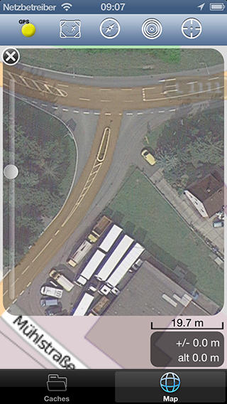
On iPhone 5 the image has a offset to the normal map. I already fixed that bug and version 1.2.2 is in review by Apple.
Additionally I will give you a update about the coming vector maps. The main implementation is done. I converted and uploaded maps of all countries to my server. After some fine-tuning (like adding the possibility to delete downloaded maps) I will start the beta tests.