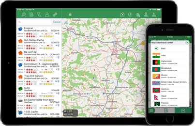
Wenn auch Dir ordentliches Kartenmaterial wichtig ist und die Standard Apple Karten Dir nicht ausreichen, sind vielleicht die Vektor Karten genau das richtige. Wie wäre es mit vollen OSM Details, kombiniert mit Höhenlinien in 25 Meter Schritten, und das auch noch Offline für ein ganzes Land?
Cannot change distance settings to feet/miles.
There is a setting in the configuration under „Language & Units“. Did you changed this setting?
How can I search for an address/city/postal code on the map?
On the map there is no function to search for a location. But if you want to search caches on a specific address, you can do it on the search view. For this tap on the icon beside the coordinate field.
Also, can I save offline a smaller, custom map? The map for British Columbia, Canada is a huge file and I only need a small area
Custom maps are not possible. Have you see the option „Download with contour lines“ on the bottom? Without contour lines the map of BC have 800 MB´s.
Ok, thanks. If you ever decide to break BC up into smaller areas, I suggest one for Vancouver Island/Gulf Islands 🙂
Today when I opened the app and then opened a list in map view, all of the caches shown have a label on them. This completely blocks up the screen making it virtually unusable.
I’d post a photograph if I could to show you what I mean. I’ve tried altering the settings but to no avail. Please help.
There are one setting which is responsible for the labels on the map. In the settings go to „Map“ and scroll down to „Caches and Waypoints“. There increase the value of „Show Labels from Zoom“. 15 is a good value..
After changing this setting, go in the map view and zoom one time completely out and in or just restart the app by killing it.
I have two „live“ icons showing on the map which toggle activate and deactivate Live map. How do I remove them from the map.
With drag&drop you can place actions from the action list on the map. To remove a already dropped action open the action list (using the wrench-icon) and scroll down. Drag the trash icon on the action you want to remove.
Is there a way to just display a compass?
No, there is only a compass on the map, no standalone compass view. You can tap in the compass, than it doubles it´s size.
Ich habe die neueste Version von L4C pro. Leider bekomme ich die gekaufte Schummerung nicht zum Laufen und der Download von Hillshades funktioniert bei mir nicht. Woran könnte das liegen? Danke für eine Antwort! Joachim
Hi, in the “map download center” when i want to download a map of Czech republic, there is a number of MB´s to download and it says 288 MB/420 MB. How big is the Map? 288 or 420 MB? IMHO 420 MB is with conture lines, but there is no more checkbox “Download sith contur lines”… How can i download the bigger Map?
Hi Jan,
since version 2.4 the contour lines are always included in the maps.There I done some rework of the maps where they fit in much smaller file sizes.
288 MB is the „zipped“ file size (downloaded through the network) and 420 MB is the extracted file size (space needed on device).
Ich habe Probleme den richtigen Zoom für die Karte einzustellen.
Wie mache ich das richtig ?
Wenn ich durchsetze öffne ist halb Deutschland offen aber nicht auf meine direkt Umgebung gezoomt
MAPS >> OFFLINE MAPS
Using L4C Pro, I have a lot of offline maps loaded but the list is displayed in a totally random order. Maps are NOT displayed in any logical order, i.e. alphabetical (preferred) or file size or even date when installed/created. Maps having similar names are not grouped together. I installed several similarly named maps (e.g. GBSxxx, GBSxxy, GBSxxz) at the same time but they appear spread out within the list randomly.
This is a huge problem when trying to find a specific map.
I’m sure in the past maps were at least grouped in some order and easy to find – I think it was in the preferred alphabetical order. This changed I believe in the past 12/18 months.
Please try to correct this problem and list offline maps in, say, alphabetical order.
Thanks for a brilliant app, Richard
Hello! I like your mAPP for iPhone very much. But is there a mAPP for android-phones?
If not. Are you planning to create a mAPP for android?
I am working with searching for people who has disappered. It would be very good if all the searchers could download mAPP and we with the GPX-files could know exactky were the searchers has been.
Thanks / Daniel
Hi Daniel,
mAPP is for iOS only. I have no plans to develop it for Android too. On Android I would recommend Locus, which is a very powerful mapping app.
Best, Thorsten
I dint like that the map aways points north. Hiw can I change the setting for the map to rotate to my direction of travel? Or, at least so I van rotate the as I choose. Does the paid version offer these features?
The heading map is included in both versions. Just press the middle button above the map.
The download of offline maps via Map Download Center in L4C doesn‘t work any more. I tried it yesterday and today with iPhone and iPad and received an error message „request failed: internal server error (500)“.
It should work again now.
Hi Thorsten
Die offline map im download center “Islas canarias“ enthält „nur“ Höhenlinien, leider keine Straßen.
Gruß
Michaela
Hallo Michaela,
ich habe nachgeschaut woran es liegt und auch gefunden. Gerade werden noch einige Karten für 12/2020 berechnet. Sobald das fertig ist lasse ich die Kanaren neu erstellen.
Danke für die Info.
Viele Grüße, Thorsten
Hi Thorsten,
Nach Update der Karte von Bayern 01/21 auf 02/21 stürzt die Pro-App beim Umschalten auf due Kartenansicht jedes Mal ab. Löschen der Datenbanken habe ich ohne Erfolg schon gemacht, die App-Neuinstallation möchte ich (natürlich) möglicht vermeiden. Hast Du vielleicht einen Tipp?
Viele Grüße, Peter
Hallo Peter,
die Datei an sich scheint fehlerhaft zu sein. Ich habe diese jetzt mal vom Download entfernt, das es nicht noch mehreren so geht.
Leider kommst Du in L4C nicht in den Bereich um die Karte zu löschen. Auch per iTunes/Finder kann die Karte nicht gelöscht werden, da das Verzeichnis nicht zugängig ist. Du kannst aber meine App „mAPP“ installieren (ist Kostenlos). Diese greift auf die gleichen Karten zu. Verwende dann den Globus oben links um die Kartenliste zu öffnen. Dort dann mit Swipe die Bayern 02/2021 Karte löschen. Sei aber vorsichtig, das Du diese nicht ausersehen auch in mAPP lädst. Durch das löschen in mAPP ist diese auch in L4C gelöscht.
Viele Grüße,
Thorsten
Bei der Deutschland Karte 9/2021 sind offensichtlich diverse Fehler drin. Straßen werden nicht angezeigt und/oder nicht durchgängig gezeigt!
Hallo,
die OpenStreetMaps Karte von Europa ist mittlerweile so groß geworden, das meinem Server beim zerlegen in die einzelnen Länder der RAM ausgegangen ist. Ich habe den Prozess etwas umgestellt, damit er wieder durchläuft. Die Karten von Deutschland sind schon fertig, andere Länder werden gerade noch berechnet.
Einfach die Karte löschen und neu laden. In den Einstellungen am Besten „Karten-Cache löschen“ verwenden, das bereits berechnete Bereiche neu berechnet werden.
Viele Grüße,
Thorsten